
Make a donation
Gear up for your next adventure:
As an Amazon Associate, this site earns from qualifying purchases at no extra cost to you.
Orscholz topographic map
Click on the map to display elevation.
Make a donation
Gear up for your next adventure:
As an Amazon Associate, this site earns from qualifying purchases at no extra cost to you.
Orscholz
Orscholz liegt auf dem Saargau. Der obere Saargau ist der Höhenzug zwischen Saar und Mosel, er wird dort auch Moselgau genannt. Er beginnt im Süden bei Merzig und zieht sich westlich an der französischen Grenze entlang. Der nördliche Teil wird von der Mosel begrenzt und der Ostrand fällt steil zum Saartal hin ab. Die Gaulandschaft ist weit und hügelig. Orscholz ist der Hauptort des oberen Saargaus (Gemeinden Mettlach und Perl).
Make a donation
Gear up for your next adventure:
As an Amazon Associate, this site earns from qualifying purchases at no extra cost to you.
About this map
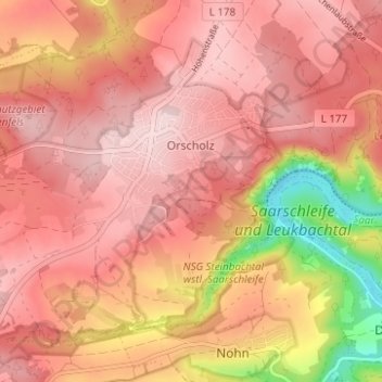
Name: Orscholz topographic map, elevation, terrain.
Average elevation: 1,184 ft
Minimum elevation: 528 ft
Maximum elevation: 1,391 ft
Make a donation
Gear up for your next adventure:
As an Amazon Associate, this site earns from qualifying purchases at no extra cost to you.
Other topographic maps
Click on a map to view its topography, its elevation and its terrain.