
Make a donation
Gear up for your next adventure:
As an Amazon Associate, this site earns from qualifying purchases at no extra cost to you.
Tembisa topographic map
Click on the map to display elevation.
Make a donation
Gear up for your next adventure:
As an Amazon Associate, this site earns from qualifying purchases at no extra cost to you.
About this map
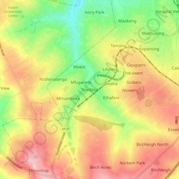
Name: Tembisa topographic map, elevation, terrain.
Average elevation: 5,230 ft
Minimum elevation: 4,934 ft
Maximum elevation: 5,492 ft
Make a donation
Gear up for your next adventure:
As an Amazon Associate, this site earns from qualifying purchases at no extra cost to you.
Other topographic maps
Click on a map to view its topography, its elevation and its terrain.
Daveyton
South Africa > Gauteng > City of Ekurhuleni Metropolitan Municipality
Average elevation: 5,292 ft
Daveyton
South Africa > Gauteng > City of Ekurhuleni Metropolitan Municipality
Average elevation: 5,292 ft
Daveyton
South Africa > Gauteng > City of Ekurhuleni Metropolitan Municipality
Average elevation: 5,292 ft
Blaaupan Dam
South Africa > Gauteng > City of Ekurhuleni Metropolitan Municipality
Average elevation: 5,433 ft
Make a donation
Gear up for your next adventure:
As an Amazon Associate, this site earns from qualifying purchases at no extra cost to you.
Etwatwa
South Africa > Gauteng > City of Ekurhuleni Metropolitan Municipality
Average elevation: 5,285 ft
Bill Stewart Nature Reserve
South Africa > Gauteng > City of Ekurhuleni Metropolitan Municipality
Average elevation: 5,561 ft