
Thank you for supporting this site ❤️
Make a donation
Make a donation
Gear up for your next adventure:
As an Amazon Associate, this site earns from qualifying purchases at no extra cost to you.
Casemasce topographic map
Click on the map to display elevation.
Thank you for supporting this site ❤️
Make a donation
Make a donation
Gear up for your next adventure:
As an Amazon Associate, this site earns from qualifying purchases at no extra cost to you.
About this map
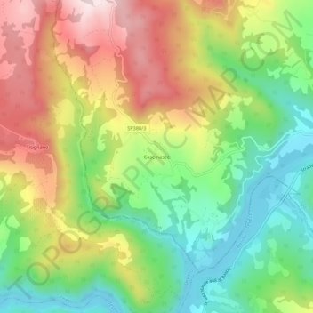
Name: Casemasce topographic map, elevation, terrain.
Location: Casemasce, Todi, Perugia, Umbria, 06059, Italia (42.73566 12.28828 42.77566 12.32828)
Average elevation: 1,102 ft
Minimum elevation: 420 ft
Maximum elevation: 1,978 ft
Thank you for supporting this site ❤️
Make a donation
Make a donation
Gear up for your next adventure:
As an Amazon Associate, this site earns from qualifying purchases at no extra cost to you.