Geolocate

Hondo topographic map

Click on the map to display elevation.

About this map

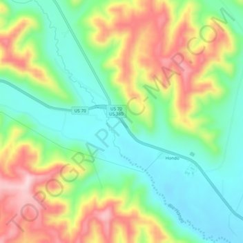
Name: Hondo topographic map, elevation, terrain.

Location: Hondo, Lincoln County, New Mexico, 88356, United States (33.36759 -105.29082 33.40759 -105.25082)

Average elevation: 5,502 ft

Minimum elevation: 5,157 ft

Maximum elevation: 6,020 ft

Lincoln County trails, hiking, mountain biking, running and outdoor activities

Gear up for your next adventure:

🛠️Backpacking Tool Kit - Essential toolkit for outdoor repairs
🌐World Map Poster - Decorative world maps with topographic info
🛰️Handheld GPS Units - Professional satellite navigators for precise backcountry mapping
🦶Hiking Gaiters - Keep debris and water out of your boots
🩳Quick‑Dry Hiking Shorts - Comfortable and quick‑dry shorts for summer hiking

As an Amazon Associate, this site earns from qualifying purchases at no extra cost to you.