
Make a donation
Gear up for your next adventure:
As an Amazon Associate, this site earns from qualifying purchases at no extra cost to you.
Boosmansbos topographic map
Click on the map to display elevation.
Make a donation
Gear up for your next adventure:
As an Amazon Associate, this site earns from qualifying purchases at no extra cost to you.
About this map
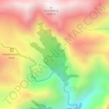
Name: Boosmansbos topographic map, elevation, terrain.
Average elevation: 3,684 ft
Minimum elevation: 1,765 ft
Maximum elevation: 5,282 ft
Make a donation
Gear up for your next adventure:
As an Amazon Associate, this site earns from qualifying purchases at no extra cost to you.
Other topographic maps
Click on a map to view its topography, its elevation and its terrain.
Klip River
South Africa > Western Cape > Overberg District Municipality > Swellendam Local Municipality > Swellendam
Average elevation: 1,063 ft
Spitskop
South Africa > Western Cape > Overberg District Municipality > Swellendam Local Municipality
Average elevation: 1,775 ft
Ouplaas
South Africa > Western Cape > Overberg District Municipality > Swellendam Local Municipality > Ouplaas
Average elevation: 443 ft
Stormsvlei
South Africa > Western Cape > Overberg District Municipality > Swellendam Local Municipality
Average elevation: 486 ft
Make a donation
Gear up for your next adventure:
As an Amazon Associate, this site earns from qualifying purchases at no extra cost to you.
Barrydale
South Africa > Western Cape > Overberg District Municipality > Swellendam Local Municipality
Average elevation: 1,394 ft