Geolocate

Fargo topographic map

Click on the map to display elevation.

About this map

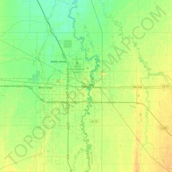
Name: Fargo topographic map, elevation, terrain.

Location: Fargo, Cass County, North Dakota, 58102-4608, United States (46.71723 -96.94982 47.03723 -96.62982)

Average elevation: 909 ft

Minimum elevation: 876 ft

Maximum elevation: 942 ft

Cass County trails, hiking, mountain biking, running and outdoor activities

Other topographic maps

Click on a map to view its topography, its elevation and its terrain.

Trollwood Park

United States > North Dakota > Cass County > Fargo

Average elevation: 899 ft

Gear up for your next adventure:

🏔️Mountain Trail Maps - High‑detail maps for popular peaks
🪵Folding Camp Saw - Compact saw for wood and campsite work
🔌Solar Panel Charger - Charge gear sustainably outdoors
🕶️GPS Smartphone Mount - Secure mount for phone navigation
🗻Climbing Gear Basics - Essential gear for beginner climbers

As an Amazon Associate, this site earns from qualifying purchases at no extra cost to you.