
Make a donation
Gear up for your next adventure:
As an Amazon Associate, this site earns from qualifying purchases at no extra cost to you.
Óutara topographic map
Click on the map to display elevation.
Make a donation
Gear up for your next adventure:
As an Amazon Associate, this site earns from qualifying purchases at no extra cost to you.
About this map
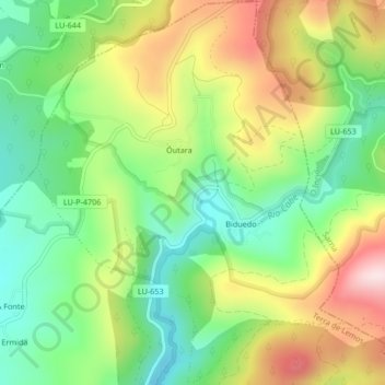
Name: Óutara topographic map, elevation, terrain.
Average elevation: 1,962 ft
Minimum elevation: 1,444 ft
Maximum elevation: 2,710 ft
Make a donation
Gear up for your next adventure:
As an Amazon Associate, this site earns from qualifying purchases at no extra cost to you.
Other topographic maps
Click on a map to view its topography, its elevation and its terrain.
Make a donation
Gear up for your next adventure:
As an Amazon Associate, this site earns from qualifying purchases at no extra cost to you.
Alto de Santa Lucía
España > Galicia > Tierra de Lemos > A Pobra do Brollón
Average elevation: 1,453 ft
Pacios de Veiga
España > Galicia > Tierra de Lemos > A Pobra do Brollón > Pacios de Veiga
Average elevation: 1,539 ft