
Thank you for supporting this site ❤️
Make a donation
Make a donation
Gear up for your next adventure:
As an Amazon Associate, this site earns from qualifying purchases at no extra cost to you.
Srirangarajapuram topographic map
Click on the map to display elevation.
Thank you for supporting this site ❤️
Make a donation
Make a donation
Gear up for your next adventure:
As an Amazon Associate, this site earns from qualifying purchases at no extra cost to you.
About this map
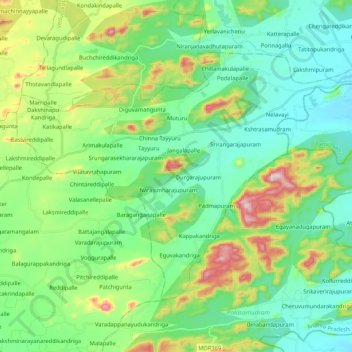
Name: Srirangarajapuram topographic map, elevation, terrain.
Location: Srirangarajapuram, Chittoor, Andhra Pradesh, 517167, India (13.20871 79.22838 13.35355 79.43902)
Average elevation: 906 ft
Minimum elevation: 518 ft
Maximum elevation: 1,942 ft
Thank you for supporting this site ❤️
Make a donation
Make a donation
Gear up for your next adventure:
As an Amazon Associate, this site earns from qualifying purchases at no extra cost to you.