
Make a donation
Gear up for your next adventure:
As an Amazon Associate, this site earns from qualifying purchases at no extra cost to you.
Kirchrarbach topographic map
Click on the map to display elevation.
Make a donation
Gear up for your next adventure:
As an Amazon Associate, this site earns from qualifying purchases at no extra cost to you.
Kirchrarbach
Kirchrarbach liegt im Rarbachtal zwischen Hanxleden und Sögtrop auf etwa 390 m Höhe. Das Tal wird im Norden vom Ehrenberg (621 m) und dem Steimel (etwa 540 m) und im Süden von der Istert (582 m) und dem Ringelskopf (557 m) begrenzt. Von diesen Höhen fließen Deitmecke, Sungesiepen, Pamecke und unterhalb der Ortsmitte als längster Bach die Sellmecke in den Rarbach. Um das Dorf liegt das Landschaftsschutzgebiet Ortsrandlage Kirchrarbach.
Make a donation
Gear up for your next adventure:
As an Amazon Associate, this site earns from qualifying purchases at no extra cost to you.
About this map
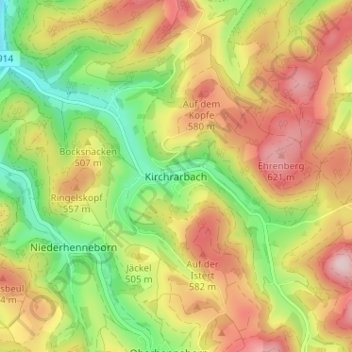
Name: Kirchrarbach topographic map, elevation, terrain.
Average elevation: 1,614 ft
Minimum elevation: 1,132 ft
Maximum elevation: 2,113 ft
Make a donation
Gear up for your next adventure:
As an Amazon Associate, this site earns from qualifying purchases at no extra cost to you.
Other topographic maps
Click on a map to view its topography, its elevation and its terrain.
Esenbeck
Deutschland > Nordrhein-Westfalen > Hochsauerlandkreis > Schmallenberg > Obersorpe
Average elevation: 2,254 ft