Geolocate

Dumka topographic map

Click on the map to display elevation.

Dumka

Dumka is located at 24°16′N 87°15′E / 24.27°N 87.25°E / 24.27; 87.25. It has an average elevation of 137 metres (449 feet).

Wikipedia (CC-BY-SA 3.0)

About this map

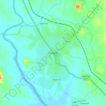
Name: Dumka topographic map, elevation, terrain.

Location: Dumka, Jharkhand, 814101, India (24.22779 87.20855 24.30779 87.28855)

Average elevation: 472 ft

Minimum elevation: 387 ft

Maximum elevation: 909 ft

Gear up for your next adventure:

🌡️Handheld Weather Meters - Measure wind, temp, and pressure for safe mountain travel
🪶Multi‑Purpose Knife - Useful blade for camp and trail
🌐World Map Poster - Decorative world maps with topographic info
😴Insulated Sleeping Pads - Compact and warm pads for high-elevation camping
🦶Carbon Trekking Poles - Reduce knee impact on steep descents with ultra-light poles

As an Amazon Associate, this site earns from qualifying purchases at no extra cost to you.