Geolocate

Little Meadows topographic map

Click on the map to display elevation.

About this map

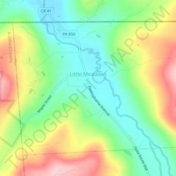
Name: Little Meadows topographic map, elevation, terrain.

Location: Little Meadows, Susquehanna County, Pennsylvania, 18830, United States (41.97790 -76.14569 41.99892 -76.10928)

Average elevation: 1,263 ft

Minimum elevation: 997 ft

Maximum elevation: 1,680 ft

Susquehanna County trails, hiking, mountain biking, running and outdoor activities

Other topographic maps

Click on a map to view its topography, its elevation and its terrain.

Lawton

United States > Pennsylvania > Susquehanna County

Average elevation: 1,168 ft

Ararat

United States > Pennsylvania > Susquehanna County

Average elevation: 2,001 ft

Forest Lake

United States > Pennsylvania > Susquehanna County

Average elevation: 1,631 ft

Springville

United States > Pennsylvania > Susquehanna County

Average elevation: 1,276 ft

Kingsley

United States > Pennsylvania > Susquehanna County

Average elevation: 1,319 ft

Brooklyn

United States > Pennsylvania > Susquehanna County > Brooklyn

Average elevation: 1,335 ft

Gear up for your next adventure:

🪶Thermal Camp Blanket - Extra warmth for cold nights
🎁Geography Themed Gifts - Unique gift ideas for map lovers and geography enthusiasts
🥾Hiking Shoes - Durable and comfortable shoes for trail hiking
🧭GPS Watch Accessories - Bands and chargers for GPS watches
🎒Waterproof Dry Bags - Keep your electronics and maps dry inside your pack

As an Amazon Associate, this site earns from qualifying purchases at no extra cost to you.