
Honalli topographic map
Interactive map
Click on the map to display elevation.
About this map
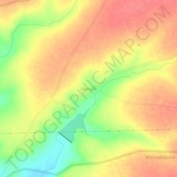
Name: Honalli topographic map, elevation, terrain.
Location: Honalli, Alanda taluku, Kalaburagi District, Karnataka, India (17.57033 76.58085 17.61033 76.62085)
Average elevation: 1,772 ft
Minimum elevation: 1,637 ft
Maximum elevation: 1,850 ft
Other topographic maps
Click on a map to view its topography, its elevation and its terrain.
Kadaganchi
India > Karnataka > Alanda taluku
Kadaganchi, Alanda taluku, Kalaburagi District, Karnataka, 585311, India
Average elevation: 1,732 ft
Nimbarga
India > Karnataka > Alanda taluku
Nimbarga, Alanda taluku, Kalaburagi District, Karnataka, India
Average elevation: 1,450 ft