
Kadaganchi topographic map
Interactive map
Click on the map to display elevation.
About this map
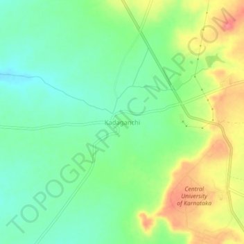
Name: Kadaganchi topographic map, elevation, terrain.
Average elevation: 1,732 ft
Minimum elevation: 1,634 ft
Maximum elevation: 1,886 ft
Other topographic maps
Click on a map to view its topography, its elevation and its terrain.
Nimbarga
India > Karnataka > Alanda taluku
Nimbarga, Alanda taluku, Kalaburagi District, Karnataka, India
Average elevation: 1,450 ft
Honalli
India > Karnataka > Alanda taluku
Honalli, Alanda taluku, Kalaburagi District, Karnataka, India
Average elevation: 1,772 ft