
Make a donation
Gear up for your next adventure:
As an Amazon Associate, this site earns from qualifying purchases at no extra cost to you.
Danau Sipin topographic map
Click on the map to display elevation.
Make a donation
Gear up for your next adventure:
As an Amazon Associate, this site earns from qualifying purchases at no extra cost to you.
About this map
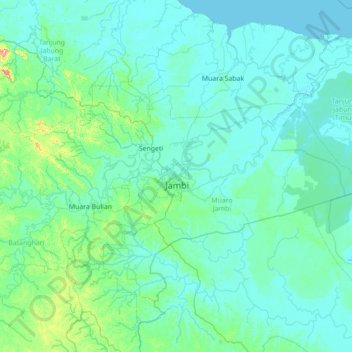
Name: Danau Sipin topographic map, elevation, terrain.
Location: Danau Sipin, Jambi, Sumatra, 36111, Indonesia (-2.29655 102.90623 -0.89655 104.30623)
Average elevation: 75 ft
Minimum elevation: -7 ft
Maximum elevation: 1,204 ft
Make a donation
Gear up for your next adventure:
As an Amazon Associate, this site earns from qualifying purchases at no extra cost to you.
Other topographic maps
Click on a map to view its topography, its elevation and its terrain.
Jambi
The total land area of Jambi city is 205.38 km2 (79 sq mi). Jambi City is located at the south-western portion of the Sumatran Basin, a low-lying area in Eastern Sumatra with an altitude of 0 to 60m above sea level. A segment of the Batanghari River, the longest river in Sumatra at 1,700 km (1,056 mi), flows…
Average elevation: 72 ft
Make a donation
Gear up for your next adventure:
As an Amazon Associate, this site earns from qualifying purchases at no extra cost to you.