
Make a donation
Gear up for your next adventure:
As an Amazon Associate, this site earns from qualifying purchases at no extra cost to you.
Tielt topographic map
Click on the map to display elevation.
Make a donation
Gear up for your next adventure:
As an Amazon Associate, this site earns from qualifying purchases at no extra cost to you.
Tielt
Tielt ligt in Zandlemig Vlaanderen, op het Plateau van Tielt. Het betreft een cuestarug die zich uitstrekt van Aarsele tot Koolskamp. Tielt ligt aan de Poekebeek die in oostelijke richting stroomt. De hoogte bedraagt 14 tot 51 meter. Van landschappelijk belang is de Poelberg, een geïsoleerde heuvel van ruim 40 meter hoogte ten zuidoosten van Tielt.
Make a donation
Gear up for your next adventure:
As an Amazon Associate, this site earns from qualifying purchases at no extra cost to you.
About this map
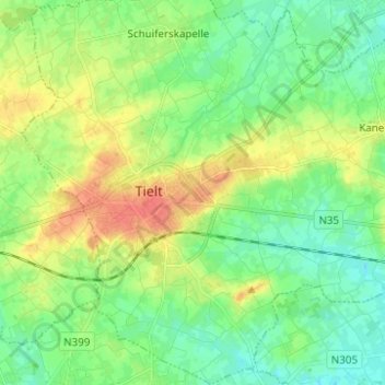
Name: Tielt topographic map, elevation, terrain.
Location: Tielt, West-Vlaanderen, Vlaanderen, 8700, België (50.96107 3.28629 51.03894 3.38218)
Average elevation: 79 ft
Minimum elevation: 26 ft
Maximum elevation: 167 ft
Make a donation
Gear up for your next adventure:
As an Amazon Associate, this site earns from qualifying purchases at no extra cost to you.
Other topographic maps
Click on a map to view its topography, its elevation and its terrain.