
La Maielletta topographic map
Interactive map
Click on the map to display elevation.
About this map
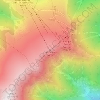
Name: La Maielletta topographic map, elevation, terrain.
Location: La Maielletta, Roccamorice, Pescara, Abruzzo, Italy (42.15752 14.12628 42.15762 14.12638)
Average elevation: 5,558 ft
Minimum elevation: 3,238 ft
Maximum elevation: 7,005 ft
Other topographic maps
Click on a map to view its topography, its elevation and its terrain.
Pagliari
Italy > Abruzzo > Pescara > Roccamorice
Pagliari, Roccamorice, Pescara, Abruzzo, Italy
Average elevation: 2,044 ft
Fonte Tettone
Italy > Abruzzo > Pescara > Roccamorice
Fonte Tettone, Roccamorice, Pescara, Abruzzo, Italy
Average elevation: 4,944 ft