Hohensaas topographic map
Interactive map
Click on the map to display elevation.
About this map
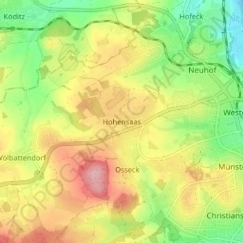
Name: Hohensaas topographic map, elevation, terrain.
Location: Hohensaas, Hof, Bayern, 95030, Deutschland (50.29356 11.85657 50.33356 11.89657)
Average elevation: 1,785 ft
Minimum elevation: 1,539 ft
Maximum elevation: 2,057 ft
Other topographic maps
Click on a map to view its topography, its elevation and its terrain.
Hof
Deutschland > Bayern > Hof
Hof, Oberfranken, Bayern, 95028, Deutschland
Average elevation: 1,716 ft
Rosenbühl
Deutschland > Bayern > Hof > Osseck
Rosenbühl, Osseck, Hof, Bayern, 95030, Deutschland
Average elevation: 1,768 ft
Unterkotzau
Deutschland > Bayern > Hof > Unterkotzau
Unterkotzau, Hof, Bayern, 95030, Deutschland
Average elevation: 1,670 ft
Haidt
Deutschland > Bayern > Hof > Haidt
Haidt, Hof, Bayern, 95028, Deutschland
Average elevation: 1,729 ft
Osseck
Deutschland > Bayern > Hof > Osseck
Osseck, Hof, Bayern, 95030, Deutschland
Average elevation: 1,808 ft
Alsenberg
Deutschland > Bayern > Hof > Alsenberg
Alsenberg, Hof, Bayern, 95028, Deutschland
Average elevation: 1,673 ft