
Cheaha State Park topographic map
Click on the map to display elevation.
About this map
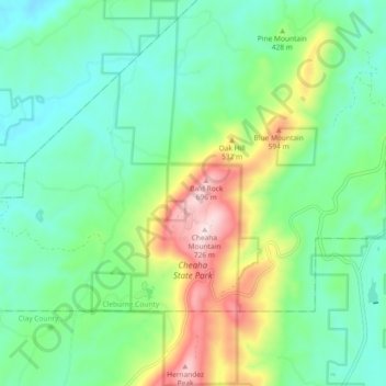
Name: Cheaha State Park topographic map, elevation, terrain.
Location: Cheaha State Park, Cleburne County, Alabama, United States (33.45460 -85.82647 33.53120 -85.79997)
Average elevation: 1,266 ft
Minimum elevation: 794 ft
Maximum elevation: 2,405 ft
Cleburne County trails, hiking, mountain biking, running and outdoor activities
Other topographic maps
Click on a map to view its topography, its elevation and its terrain.
Cheaha Mountain
United States > Alabama > Cleburne County
Cheaha Mountain is part of the Talladega Mountains, a small section of the Ridge and Valley Mountains, unlike other elevations of the Appalachians in north Alabama, which are part of the Cumberland Plateau. The mountain is the highest point in the eastern portion of the Sun Belt (east of the Mississippi River,…
Average elevation: 1,781 ft
Choccolocco Wildlife Management Area
United States > Alabama > Cleburne County
Average elevation: 1,214 ft
Cheaha Mountain
United States > Alabama > Cleburne County
Cheaha Mountain is part of the Talladega Mountains, a small section of the Ridge and Valley Mountains, unlike other elevations of the Appalachians in north Alabama, which are part of the Cumberland Plateau. The mountain is the highest point in the eastern portion of the Sun Belt (east of the Mississippi River,…
Average elevation: 1,781 ft