
Make a donation
Gear up for your next adventure:
As an Amazon Associate, this site earns from qualifying purchases at no extra cost to you.
Iqaluit topographic map
Click on the map to display elevation.
Make a donation
Gear up for your next adventure:
As an Amazon Associate, this site earns from qualifying purchases at no extra cost to you.
Iqaluit
Iqaluit has a tundra climate (Köppen: ET) typical of the Arctic region, although it is well outside the Arctic Circle. The city features long, cold winters and brief, cool summers. Average monthly temperatures are below freezing for eight months of the year. Iqaluit averages just over 400 mm (16 in) of precipitation annually, much wetter than many other localities in the Arctic Archipelago, with the summer being the wettest season. Temperatures of the winter months are comparable to other northern communities further west on the continent such as Yellowknife and to some extent even Fairbanks, Alaska, even though Iqaluit is a few degrees colder than the latter. Summer temperatures are, however, much colder due to its easterly maritime position affected by the waters of the cold Baffin Island Current. This means that the tree line is much further south in the eastern part of Canada, being as southbound, in spite of low elevation, as northern Labrador.
Make a donation
Gear up for your next adventure:
As an Amazon Associate, this site earns from qualifying purchases at no extra cost to you.
About this map
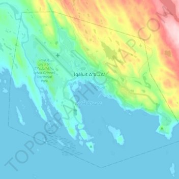
Name: Iqaluit topographic map, elevation, terrain.
Location: Iqaluit, ᐃᖃᓗᐃᑦ, Qikiqtaaluk Region, Nunavut, Canada (63.70852 -68.60121 63.77634 -68.42543)
Average elevation: 164 ft
Minimum elevation: 0 ft
Maximum elevation: 820 ft
Make a donation
Gear up for your next adventure:
As an Amazon Associate, this site earns from qualifying purchases at no extra cost to you.
Other topographic maps
Click on a map to view its topography, its elevation and its terrain.