
Thank you for supporting this site ❤️
Make a donation
Make a donation
Gear up for your next adventure:
As an Amazon Associate, this site earns from qualifying purchases at no extra cost to you.
Illhorn topographic map
Click on the map to display elevation.
Thank you for supporting this site ❤️
Make a donation
Make a donation
Gear up for your next adventure:
As an Amazon Associate, this site earns from qualifying purchases at no extra cost to you.
About this map
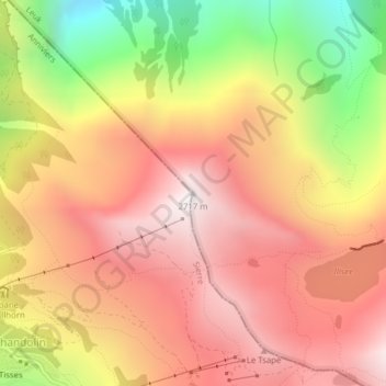
Name: Illhorn topographic map, elevation, terrain.
Location: Illhorn, Leuk Stadt, Leuk, Wallis, 3952, Schweiz (46.26293 7.61617 46.26303 7.61627)
Average elevation: 7,103 ft
Minimum elevation: 4,423 ft
Maximum elevation: 8,875 ft
Thank you for supporting this site ❤️
Make a donation
Make a donation
Gear up for your next adventure:
As an Amazon Associate, this site earns from qualifying purchases at no extra cost to you.