
Make a donation
Gear up for your next adventure:
As an Amazon Associate, this site earns from qualifying purchases at no extra cost to you.
Ghatsila topographic map
Click on the map to display elevation.
Make a donation
Gear up for your next adventure:
As an Amazon Associate, this site earns from qualifying purchases at no extra cost to you.
Ghatsila
Ghatshila is located at 22°36′N 86°29′E / 22.60°N 86.48°E / 22.60; 86.48. It has an average elevation of 103 m (338 ft).
Make a donation
Gear up for your next adventure:
As an Amazon Associate, this site earns from qualifying purchases at no extra cost to you.
About this map
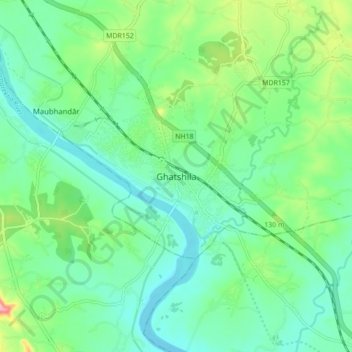
Name: Ghatsila topographic map, elevation, terrain.
Location: Ghatsila, Ghatshila, East Singhbhum, Jharkhand, 832303, India (22.54531 86.43682 22.62531 86.51682)
Average elevation: 351 ft
Minimum elevation: 233 ft
Maximum elevation: 673 ft
Make a donation
Gear up for your next adventure:
As an Amazon Associate, this site earns from qualifying purchases at no extra cost to you.