
Rayasandra topographic map
Interactive map
Click on the map to display elevation.
About this map
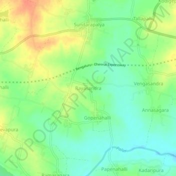
Name: Rayasandra topographic map, elevation, terrain.
Average elevation: 2,523 ft
Minimum elevation: 2,461 ft
Maximum elevation: 2,605 ft
Other topographic maps
Click on a map to view its topography, its elevation and its terrain.
Kammasandra
India > Karnataka > Kolar Gold Field taluk
Kammasandra, Kolar Gold Field taluk, Kolar District, Karnataka, 563116, India
Average elevation: 2,661 ft
Urigam
India > Karnataka > Kolar Gold Field taluk
Urigam, Kolar Gold Field taluk, Kolar District, Karnataka, 563122, India
Average elevation: 2,762 ft
Kolar Gold Fields
India > Karnataka > Kolar Gold Field taluk
Kolar Gold Fields, Kolar Gold Field taluk, Kolar District, Karnataka, 563115, India
Average elevation: 2,772 ft