
Cabiri topographic map
Interactive map
Click on the map to display elevation.
About this map
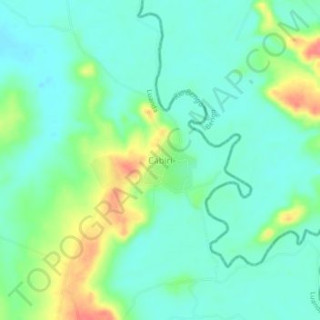
Name: Cabiri topographic map, elevation, terrain.
Location: Cabiri, Ícolo and Bengo Municipality, Luanda Province, Angola (-8.94087 13.64523 -8.90087 13.68523)
Average elevation: 79 ft
Minimum elevation: 16 ft
Maximum elevation: 220 ft
Other topographic maps
Click on a map to view its topography, its elevation and its terrain.
Ícolo and Bengo Municipality
Angola > Luanda Province > Ícolo and Bengo Municipality
Ícolo and Bengo Municipality, Luanda Province, Angola
Average elevation: 299 ft