Geolocate

Caimito topographic map

Click on the map to display elevation.

About this map

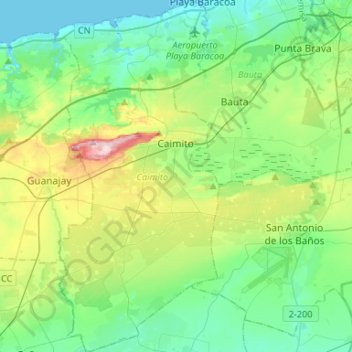
Name: Caimito topographic map, elevation, terrain.

Location: Caimito, Artemisa, Cuba (22.80762 -82.68431 23.05056 -82.56106)

Average elevation: 210 ft

Minimum elevation: 0 ft

Maximum elevation: 814 ft

Other topographic maps

Click on a map to view its topography, its elevation and its terrain.

La Conchita

Cuba > Artemisa > San Cristóbal

Average elevation: 128 ft

Soroa

Cuba > Artemisa > Candelaria

Average elevation: 673 ft

Cangrejeras

Cuba > Artemisa

Average elevation: 89 ft

Rancho Mar

Cuba > Artemisa > Bauta > Lazo de la Vega

Average elevation: 66 ft

Las Terrazas

Cuba > Artemisa > Candelaria

Average elevation: 830 ft

Portugués

Cuba > Artemisa > Artemisa > Portugués

Average elevation: 92 ft

Gear up for your next adventure:

🪶LED Camping Lantern - Bright lantern for camp lighting
🚑Emergency Bivvies - Heat-reflective sleeping bags for survival situations
🦟Ultrasonic Repellers - Create a bug-free zone at your camp or rest stop
🌐World Map Poster - Decorative world maps with topographic info
🛡️Bear Spray Outdoor - Protection in bear country hikes

As an Amazon Associate, this site earns from qualifying purchases at no extra cost to you.