Worth topographic map
Interactive map
Click on the map to display elevation.
About this map
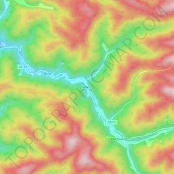
Name: Worth topographic map, elevation, terrain.
Location: Worth, McDowell County, West Virginia, 24858, United States (37.39484 -81.40982 37.43484 -81.36982)
Average elevation: 2,398 ft
Minimum elevation: 1,814 ft
Maximum elevation: 2,930 ft
Other topographic maps
Click on a map to view its topography, its elevation and its terrain.
Canebrake
United States > West Virginia > McDowell County
Canebrake, McDowell County, West Virginia, 24815, United States
Average elevation: 1,991 ft
Faraday
United States > West Virginia > McDowell County > Faraday
Faraday, McDowell County, West Virginia, 24601, United States
Average elevation: 2,096 ft
Yerba
United States > West Virginia > McDowell County
Yerba, McDowell County, West Virginia, 24828, United States
Average elevation: 1,847 ft
English
United States > West Virginia > McDowell County
English, McDowell County, West Virginia, 24813, United States
Average elevation: 1,831 ft
Welch
United States > West Virginia > McDowell County
Welch, McDowell County, West Virginia, 24801, United States
Average elevation: 1,798 ft