
Thank you for supporting this site ❤️
Make a donation
Make a donation
Gear up for your next adventure:
As an Amazon Associate, this site earns from qualifying purchases at no extra cost to you.
Raval topographic map
Click on the map to display elevation.
Thank you for supporting this site ❤️
Make a donation
Make a donation
Gear up for your next adventure:
As an Amazon Associate, this site earns from qualifying purchases at no extra cost to you.
About this map
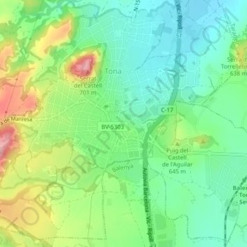
Name: Raval topographic map, elevation, terrain.
Location: Raval, Tona, Osona, Barcelona, Cataluña, 08551, España (41.84616 2.22691 41.84990 2.23282)
Average elevation: 1,978 ft
Minimum elevation: 1,808 ft
Maximum elevation: 2,297 ft
Thank you for supporting this site ❤️
Make a donation
Make a donation
Gear up for your next adventure:
As an Amazon Associate, this site earns from qualifying purchases at no extra cost to you.