Geolocate

Mukkada topographic map

Click on the map to display elevation.

About this map

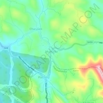
Name: Mukkada topographic map, elevation, terrain.

Location: Mukkada, Kanjirappally, Kottayam, Kerala, 686511, India (9.44190 76.78030 9.48190 76.82030)

Average elevation: 354 ft

Minimum elevation: 125 ft

Maximum elevation: 876 ft

Other topographic maps

Click on a map to view its topography, its elevation and its terrain.

Elivalikkara

India > Kerala > Kanjirappally > Mukkoottuthara

Average elevation: 548 ft

Mundakayam

India > Kerala > Kanjirappally > Kannimala

Average elevation: 433 ft

Kanjirappilly

India > Kerala > Kanjirappally

Average elevation: 748 ft

Mundakayam

India > Kerala > Kanjirappally > Punchavayal

Average elevation: 433 ft

Nadukani

India > Kerala > Kanjirappally > Mundakkayam

Average elevation: 522 ft

Gear up for your next adventure:

👖Convertible Hiking Pants - Versatile zip-off pants for changing altitudes and temperatures
Solar GPS Watches - Advanced multisport watches with built-in topographic maps
🪶Camp Gear Gift Set - Perfect gift bundle for outdoor fans
🪶Survival Guide Book - Expert advice for emergency preparedness
📡GPS Antenna Upgrade - Enhance GPS reception in remote terrain

As an Amazon Associate, this site earns from qualifying purchases at no extra cost to you.