Geolocate

Kiel topographic map

Click on the map to display elevation.

About this map

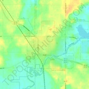
Name: Kiel topographic map, elevation, terrain.

Location: Kiel, Manitowoc County, Wisconsin, United States (43.90535 -88.05398 43.92921 -87.99760)

Average elevation: 915 ft

Minimum elevation: 869 ft

Maximum elevation: 965 ft

Manitowoc County trails, hiking, mountain biking, running and outdoor activities

Other topographic maps

Click on a map to view its topography, its elevation and its terrain.

Cato

United States > Wisconsin > Manitowoc County

Average elevation: 856 ft

Woods

United States > Wisconsin > Manitowoc County > Manitowoc

Average elevation: 686 ft

Gear up for your next adventure:

📖Nature Tracking Books - Learn to track wildlife and terrain
📶Vehicle Signal Boosters - Improve reception in rural areas while driving to trailheads
🧤Tactile Hiking Gloves - Keep hands warm while operating GPS and smartphone screens
🧭Hiking Compass - Precision compass for reliable navigation in the wilderness
🪶Thermal Camp Blanket - Extra warmth for cold nights

As an Amazon Associate, this site earns from qualifying purchases at no extra cost to you.