
Frickenhofen topographic map
Click on the map to display elevation.
Frickenhofen
Von 1271 bis 1474 ist der Ortsadel als blühendes und weit verzweigtes Geschlecht nachgewiesen, das mit Konrad und Albert auch zwei Eichstätter Domherren stellte. Der Burgstall Frickenhofen befindet sich südöstlich auf der Anhöhe im Forst „Steinlohe“. Ein Albrecht von Frickenhofen ist 1307 als Spender eines jährlichen Zinses für das Siechhaus in Lengenfeld und 1309/10 als Spender für das Kloster Kastl genannt. 1336 stifteten Albrecht und Friedrich von Frickenhofen eine eigene Kapelle bei der Klosterkirche von Seligenporten. Ende des 14. Jahrhunderts sind die Herren von Frickenhofen als Neumarkter Bürgergeschlecht anzutreffen.
About this map
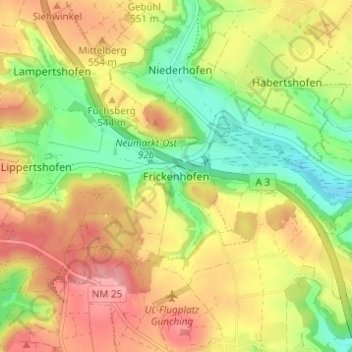
Name: Frickenhofen topographic map, elevation, terrain.
Average elevation: 1,742 ft
Minimum elevation: 1,542 ft
Maximum elevation: 1,939 ft
Other topographic maps
Click on a map to view its topography, its elevation and its terrain.
92318
Deutschland > Bayern > Landkreis Neumarkt in der Oberpfalz > Neumarkt in der Oberpfalz > Höhenberg im Tal
Average elevation: 1,683 ft