
Make a donation
Gear up for your next adventure:
As an Amazon Associate, this site earns from qualifying purchases at no extra cost to you.
Elspe topographic map
Click on the map to display elevation.
Make a donation
Gear up for your next adventure:
As an Amazon Associate, this site earns from qualifying purchases at no extra cost to you.
About this map
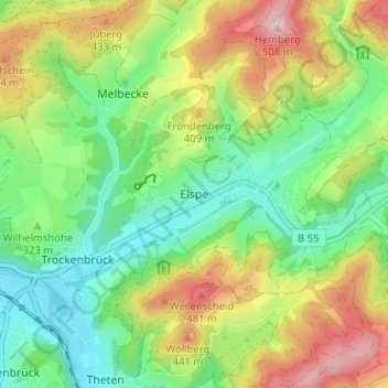
Name: Elspe topographic map, elevation, terrain.
Average elevation: 1,135 ft
Minimum elevation: 804 ft
Maximum elevation: 1,670 ft
Make a donation
Gear up for your next adventure:
As an Amazon Associate, this site earns from qualifying purchases at no extra cost to you.
Other topographic maps
Click on a map to view its topography, its elevation and its terrain.
Meggen
Deutschland > Nordrhein-Westfalen > Kreis Olpe > Lennestadt
Über Jahrzehnte hinweg wurde die Entwicklung von Meggen stark vom Bergbau beeinflusst. Der Abbau von Schwefelkies in der Umgebung begann in den 1850er-Jahren. Begünstigt wurde die Entwicklung ab 1861 durch den Anschluss an die Lennetalbahn von Hagen nach Siegen und die damit verbundene Verbesserung der…
Average elevation: 1,211 ft