
Thank you for supporting this site ❤️
Make a donation
Make a donation
Gear up for your next adventure:
As an Amazon Associate, this site earns from qualifying purchases at no extra cost to you.
Vankusawade topographic map
Click on the map to display elevation.
Thank you for supporting this site ❤️
Make a donation
Make a donation
Gear up for your next adventure:
As an Amazon Associate, this site earns from qualifying purchases at no extra cost to you.
About this map
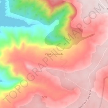
Name: Vankusawade topographic map, elevation, terrain.
Location: Vankusawade, Patan, Satara, Maharashtra, India (17.49821 73.81107 17.53821 73.85107)
Average elevation: 3,278 ft
Minimum elevation: 2,103 ft
Maximum elevation: 3,763 ft
Thank you for supporting this site ❤️
Make a donation
Make a donation
Gear up for your next adventure:
As an Amazon Associate, this site earns from qualifying purchases at no extra cost to you.