
Make a donation
Gear up for your next adventure:
As an Amazon Associate, this site earns from qualifying purchases at no extra cost to you.
Dresdner Heide topographic map
Click on the map to display elevation.
Make a donation
Gear up for your next adventure:
As an Amazon Associate, this site earns from qualifying purchases at no extra cost to you.
Dresdner Heide
Im Gegensatz zur weit verbreiteten Schreibung Dresdner Heide wird in den topographischen Landeskartenwerken die Schreibung Dresdener Heide angewandt.
Make a donation
Gear up for your next adventure:
As an Amazon Associate, this site earns from qualifying purchases at no extra cost to you.
About this map
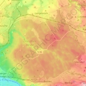
Name: Dresdner Heide topographic map, elevation, terrain.
Average elevation: 751 ft
Minimum elevation: 331 ft
Maximum elevation: 1,093 ft
Make a donation
Gear up for your next adventure:
As an Amazon Associate, this site earns from qualifying purchases at no extra cost to you.
Other topographic maps
Click on a map to view its topography, its elevation and its terrain.
Dresden
Deutschland > Sachsen > Dresden
Als Höhenreferenz für Dresden gilt der Altmarkt als zentraler Platz der Stadt mit einer Höhe von 113 m ü. NN, der Nullpunkt des Elbpegels liegt bei 102,73 m. Die höchste Erhebung im Stadtgebiet ist der rechts der Elbe gelegene 383 m hohe Triebenberg, der tiefste Punkt liegt am Elbufer in Niederwartha mit 101 m.
Average elevation: 778 ft
Make a donation
Gear up for your next adventure:
As an Amazon Associate, this site earns from qualifying purchases at no extra cost to you.
Merbitz
Deutschland > Sachsen > Dresden
Die südöstliche Flurgrenze des Ortsteils zu Ockerwitz und Omsewitz verläuft im Zschonergrund. Hier liegt zugleich mit 160 m ü. NN die tiefste Stelle der Gemarkung. Über die Merbitzer Flur verläuft in einem knapp 1 km langen Abschnitt östlich des Autobahndreiecks Dresden-West die A 4. Sie passiert den…
Average elevation: 633 ft