Geolocate

Qardho topographic map

Click on the map to display elevation.

About this map

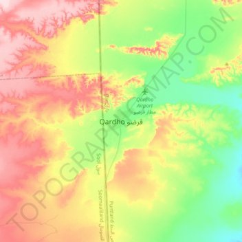
Name: Qardho topographic map, elevation, terrain.

Location: Qardho, Qardho District, Bari, Puntland, Somalia (9.34701 48.92721 9.66701 49.24721)

Average elevation: 2,556 ft

Minimum elevation: 2,238 ft

Maximum elevation: 2,979 ft

Gear up for your next adventure:

🔋Solar Power Banks - Keep your GPS and phone charged in remote wilderness areas
🧭Outdoor Navigation Book - Learn advanced navigation skills
📡Handheld GPS Device - Reliable handheld GPS for outdoor navigation
🦶Hiking Gaiters - Keep debris and water out of your boots
📦Gear Storage Bags - Organize and protect outdoor equipment

As an Amazon Associate, this site earns from qualifying purchases at no extra cost to you.