Geolocate

Tulos topographic map

Click on the map to display elevation.

About this map

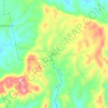
Name: Tulos topographic map, elevation, terrain.

Location: Tulos, Rosario, Batangas, Calabarzon, Philippines (13.72260 121.24872 13.76260 121.28872)

Average elevation: 725 ft

Minimum elevation: 505 ft

Maximum elevation: 1,020 ft

Gear up for your next adventure:

🛌Ultralight Sleeping Bags - Compact down bags for cold nights in the wilderness
🪶Survival Guide Book - Expert advice for emergency preparedness
👟Trail Running Shoes - Lightweight shoes for trail runners
🪶Multi‑Purpose Knife - Useful blade for camp and trail
🪑Ultralight Camp Chairs - Portable seating for resting after a long day of mapping

As an Amazon Associate, this site earns from qualifying purchases at no extra cost to you.