Make a donation
Gear up for your next adventure:
As an Amazon Associate, this site earns from qualifying purchases at no extra cost to you.
Iola topographic map
Click on the map to display elevation.
Make a donation
Gear up for your next adventure:
As an Amazon Associate, this site earns from qualifying purchases at no extra cost to you.
About this map
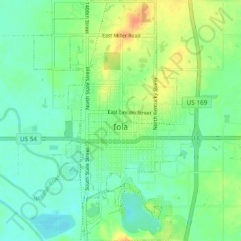
Name: Iola topographic map, elevation, terrain.
Location: Iola, Allen County, Kansas, 66749, United States (37.90013 -95.42344 37.95143 -95.37978)
Average elevation: 971 ft
Minimum elevation: 928 ft
Maximum elevation: 1,050 ft
Allen County trails, hiking, mountain biking, running and outdoor activities
Make a donation
Gear up for your next adventure:
As an Amazon Associate, this site earns from qualifying purchases at no extra cost to you.
Other topographic maps
Click on a map to view its topography, its elevation and its terrain.
