
Make a donation
Gear up for your next adventure:
As an Amazon Associate, this site earns from qualifying purchases at no extra cost to you.
Kerkhoven topographic map
Click on the map to display elevation.
Make a donation
Gear up for your next adventure:
As an Amazon Associate, this site earns from qualifying purchases at no extra cost to you.
About this map
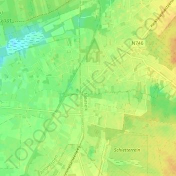
Name: Kerkhoven topographic map, elevation, terrain.
Location: Kerkhoven, Lommel, Maaseik, Limburg, 3920, België (51.13996 5.24393 51.17996 5.28393)
Average elevation: 138 ft
Minimum elevation: 92 ft
Maximum elevation: 177 ft
Make a donation
Gear up for your next adventure:
As an Amazon Associate, this site earns from qualifying purchases at no extra cost to you.
Other topographic maps
Click on a map to view its topography, its elevation and its terrain.
Lommelse Sahara
België > Limburg > Maaseik > Lommel
Op 1 april 2015 werd in de Sahara een uitkijktoren geopend met een hoogte van 30 meter. Deze indrukwekkende constructie beschikt over drie platforms die je een wijde blik op de omgeving bieden. De inspiratie voor de look van de uitkijktoren haalden de ontwerpers uit het glooiende lijnenspel van de zandduinen…
Average elevation: 151 ft