Geolocate

Pont-de-l'Isère topographic map

Click on the map to display elevation.

About this map
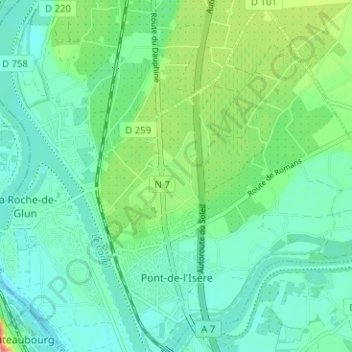
Name: Pont-de-l'Isère topographic map, elevation, terrain.

Location: Pont-de-l'Isère, Valence, Drôme, Auvergne-Rhône-Alpes, Metropolitan France, 26600, France (44.99481 4.85731 45.03933 4.90571)

Average elevation: 417 ft

Minimum elevation: 348 ft

Maximum elevation: 607 ft

Other topographic maps

Click on a map to view its topography, its elevation and its terrain.

Ferme du Mandement

France > Auvergne-Rhône-Alpes > Drôme > Bouvante

Average elevation: 3,963 ft

La Martinette

France > Auvergne-Rhône-Alpes > Drôme > Peyrus

Average elevation: 1,276 ft

Bouvante le Haut

France > Auvergne-Rhône-Alpes > Drôme > Bouvante

Average elevation: 3,110 ft

Gear up for your next adventure:

🧭GPS Watch Accessories - Bands and chargers for GPS watches
🎁Geography Themed Gifts - Unique gift ideas for map lovers and geography enthusiasts
☕Camping Coffee Makers - Enjoy premium coffee at the summit or campsite
🧺Microfiber Travel Towels - Compact and fast-drying towels for trail use
🌲Outdoor Survival Books - Best books on survival skills

As an Amazon Associate, this site earns from qualifying purchases at no extra cost to you.