
Windgap topographic map
Click on the map to display elevation.
About this map
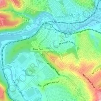
Name: Windgap topographic map, elevation, terrain.
Average elevation: 846 ft
Minimum elevation: 712 ft
Maximum elevation: 1,165 ft
Allegheny County trails, hiking, mountain biking, running and outdoor activities
Other topographic maps
Click on a map to view its topography, its elevation and its terrain.
Panther Hollow Lake
United States > Pennsylvania > Allegheny County > Pittsburgh
Average elevation: 938 ft
Black mulberry (Morus nigra)
United States > Pennsylvania > Allegheny County > Pittsburgh
Average elevation: 971 ft