
Make a donation
Gear up for your next adventure:
As an Amazon Associate, this site earns from qualifying purchases at no extra cost to you.
Bellinghoven topographic map
Click on the map to display elevation.
Make a donation
Gear up for your next adventure:
As an Amazon Associate, this site earns from qualifying purchases at no extra cost to you.
Bellinghoven
1566 denunzierten Nachbarn Frens van Bellinghoven beim Vogt von Erkelenz als Hexe. Ihre Unschuld galt als erwiesen, nachdem sie zweimal der Folter, dem peinlichen Verhör, widerstand. Das Erkelenzer Schöffengericht und das nächsthöhere Gericht in Roermond erkannten ihre Forderung auf Schadensersatz, die ihre Nachbarn zu zahlen hatten, an.
Make a donation
Gear up for your next adventure:
As an Amazon Associate, this site earns from qualifying purchases at no extra cost to you.
About this map
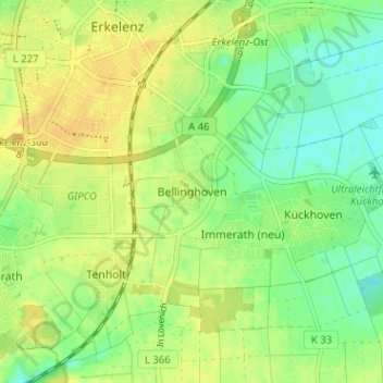
Name: Bellinghoven topographic map, elevation, terrain.
Average elevation: 312 ft
Minimum elevation: 266 ft
Maximum elevation: 344 ft
Make a donation
Gear up for your next adventure:
As an Amazon Associate, this site earns from qualifying purchases at no extra cost to you.