Geolocate

Monte Brancetta topographic map

Click on the map to display elevation.

About this map

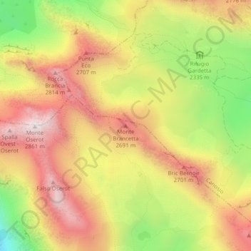
Name: Monte Brancetta topographic map, elevation, terrain.

Location: Monte Brancetta, Argentera, Cuneo, Piedmont, Italy (44.40159 7.00101 44.40169 7.00111)

Average elevation: 8,094 ft

Minimum elevation: 6,575 ft

Maximum elevation: 9,298 ft

Gear up for your next adventure:

Backpacking Tent - Lightweight and durable tent for multi‑day hikes
🧤Hiking Gloves - Protective gloves for rugged trails
Backpacking Tents - Weight-optimized shelters for multi-day topographic surveys
📷Action Camera - Capture your outdoor adventures in HD
🧥Men's Rain Shells - Premium waterproof and breathable jackets for mountain weather

As an Amazon Associate, this site earns from qualifying purchases at no extra cost to you.