
Odesheim topographic map
Click on the map to display elevation.
Odesheim
Odesheim liegt im Nordosten der Eifel, etwa 15 km südöstlich der Altstadt von Bad Münstereifel. Der Ort liegt eingebettet im Naturraum Nordeifel, unweit vom Michelsberg (588 m ü. NHN) und vom Aremberg (623 m ü. NHN). Die höchste Erhebung des Dorfes ist die Biersnück mit 468 m ü. NHN. In einer Mulde auf einer kleinen Erhebung gelegen bietet sich ein Blick auf den Aremberg, den Michelsberg und bis zu den Höhenzügen der östlichen Hocheifel mit Hohe Acht (747 m ü. NHN) und Nürburg (679 m ü. NHN).
About this map
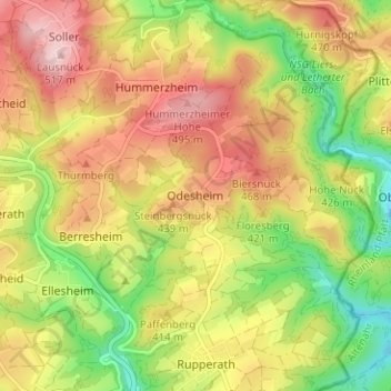
Name: Odesheim topographic map, elevation, terrain.
Average elevation: 1,309 ft
Minimum elevation: 915 ft
Maximum elevation: 1,683 ft