Geolocate

Calumpit topographic map

Click on the map to display elevation.

👉 Easily get elevation data in JSON, GeoTIFF and KML formats using Elevation API
Thank you for supporting this site ❤️
Make a donation

About this map

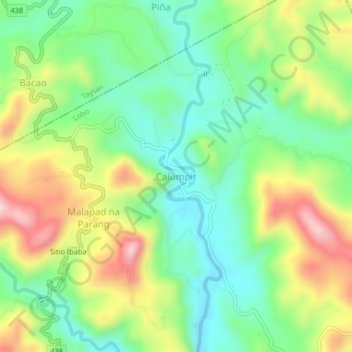
Name: Calumpit topographic map, elevation, terrain.

Location: Calumpit, Lobo, Batangas, Calabarzon, Philippines (13.68682 121.20915 13.72682 121.24915)

Average elevation: 561 ft

Minimum elevation: 135 ft

Maximum elevation: 1,247 ft

Gear up for your next adventure:

🗺️NatGeo Topo Maps - High-quality waterproof printed topographic maps of US Parks
🏫Relief Map Kits - Hands-on tools for teaching landforms and elevation
🪓Survival Multi‑Tool - Versatile tool for camp and trail tasks
🧭GPS Watch Accessories - Bands and chargers for GPS watches
🌲Outdoor Survival Books - Best books on survival skills

As an Amazon Associate, this site earns from qualifying purchases at no extra cost to you.