
Make a donation
Gear up for your next adventure:
As an Amazon Associate, this site earns from qualifying purchases at no extra cost to you.
Fultondale topographic map
Click on the map to display elevation.
Make a donation
Gear up for your next adventure:
As an Amazon Associate, this site earns from qualifying purchases at no extra cost to you.
Fultondale
Due to difficult topography, for many years Fultondale was limited in its ability to grow. However, as technology improved, the ability to convert what had been difficult to unusable land for retail and commercial purposes improved. Besides the retail development of Colonial Promenade, other retail development nearby includes Lowe's and various chain restaurants such as O'Charley's and Outback Steakhouse. Other older, more mature business establishments line US 31 in the center of the community including supermarkets, casual fast food, banks, a bowling alley and skating rink.
Make a donation
Gear up for your next adventure:
As an Amazon Associate, this site earns from qualifying purchases at no extra cost to you.
About this map
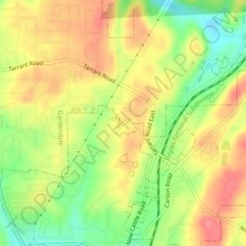
Name: Fultondale topographic map, elevation, terrain.
Location: Fultondale, Jefferson County, Alabama, United States (33.63460 -86.78918 33.63555 -86.78769)
Average elevation: 623 ft
Minimum elevation: 482 ft
Maximum elevation: 735 ft
Jefferson County trails, hiking, mountain biking, running and outdoor activities
Make a donation
Gear up for your next adventure:
As an Amazon Associate, this site earns from qualifying purchases at no extra cost to you.
Other topographic maps
Click on a map to view its topography, its elevation and its terrain.