
Make a donation
Gear up for your next adventure:
As an Amazon Associate, this site earns from qualifying purchases at no extra cost to you.
Mamoiada topographic map
Click on the map to display elevation.
Make a donation
Gear up for your next adventure:
As an Amazon Associate, this site earns from qualifying purchases at no extra cost to you.
Mamoiada
L'altitudine del territorio del comune è compresa fra i 390 m e i 1.048 m sul livello del mare.
Make a donation
Gear up for your next adventure:
As an Amazon Associate, this site earns from qualifying purchases at no extra cost to you.
About this map
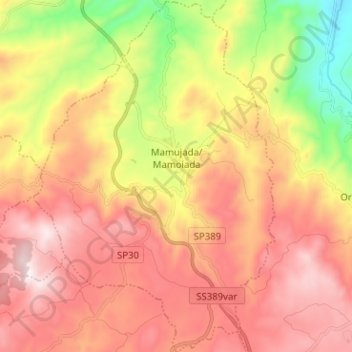
Name: Mamoiada topographic map, elevation, terrain.
Location: Mamoiada, Nuoro, Sardegna, 08024, Italia (40.16201 9.22885 40.25869 9.31571)
Average elevation: 2,379 ft
Minimum elevation: 801 ft
Maximum elevation: 3,652 ft
Make a donation
Gear up for your next adventure:
As an Amazon Associate, this site earns from qualifying purchases at no extra cost to you.
Other topographic maps
Click on a map to view its topography, its elevation and its terrain.
Make a donation
Gear up for your next adventure:
As an Amazon Associate, this site earns from qualifying purchases at no extra cost to you.