Geolocate

Warsaw topographic map

Click on the map to display elevation.

About this map

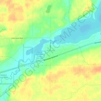
Name: Warsaw topographic map, elevation, terrain.

Location: Warsaw, Rice County, Minnesota, 55087, United States (44.22941 -93.41383 44.26941 -93.37383)

Average elevation: 1,033 ft

Minimum elevation: 971 ft

Maximum elevation: 1,093 ft

Rice County trails, hiking, mountain biking, running and outdoor activities

Other topographic maps

Click on a map to view its topography, its elevation and its terrain.

Morristown

United States > Minnesota > Rice County

Average elevation: 1,037 ft

Faribault

United States > Minnesota > Rice County

Average elevation: 1,066 ft

Gear up for your next adventure:

🛡️Insect Repellent - Protection against bugs during outdoor activities
🦶Carbon Trekking Poles - Reduce knee impact on steep descents with ultra-light poles
🌄Hiking Binoculars - Compact binoculars for scenic views and trail spotting
🔦Powerful Headlamps - Ultra-bright hands-free lighting for night navigation
🔦Compact Flashlight - Reliable flashlight for emergencies

As an Amazon Associate, this site earns from qualifying purchases at no extra cost to you.