
Make a donation
Gear up for your next adventure:
As an Amazon Associate, this site earns from qualifying purchases at no extra cost to you.
Braunsbach topographic map
Click on the map to display elevation.
Make a donation
Gear up for your next adventure:
As an Amazon Associate, this site earns from qualifying purchases at no extra cost to you.
About this map
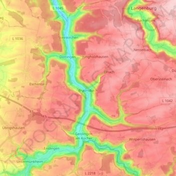
Name: Braunsbach topographic map, elevation, terrain.
Average elevation: 1,302 ft
Minimum elevation: 748 ft
Maximum elevation: 1,637 ft
Make a donation
Gear up for your next adventure:
As an Amazon Associate, this site earns from qualifying purchases at no extra cost to you.
Other topographic maps
Click on a map to view its topography, its elevation and its terrain.
Einkorn
Deutschland > Baden-Württemberg > Landkreis Schwäbisch Hall > Schwäbisch Hall
Über eine Holztreppe, deren oberste Stufen innerhalb eines an der Nordostecke des Turms angebauten Scharwachtturms verlaufen, gelangt man zur überdachten Aussichtsplattform, die auf rund 25 m Höhe liegt. Von hier hat man einen weiten Blick über die Haller und Hohenloher Ebene und ins Kochertal hinunter.…
Average elevation: 1,352 ft
Ramsbach
Deutschland > Baden-Württemberg > Landkreis Schwäbisch Hall > Schwäbisch Hall
Average elevation: 1,283 ft
Make a donation
Gear up for your next adventure:
As an Amazon Associate, this site earns from qualifying purchases at no extra cost to you.
Brachbach
Deutschland > Baden-Württemberg > Landkreis Schwäbisch Hall > Übrigshausen
Average elevation: 1,289 ft
Hessental
Deutschland > Baden-Württemberg > Landkreis Schwäbisch Hall > Schwäbisch Hall
Stadtmitte | Nördliche Kernstadt | Kreuzäcker | Südliche Kernstadt | Tullauer Höhe / Hagenbach | Rollhof / Reifenhof | Stadtheide | Heimbachsiedlung / Teurershof | Steinbach | Hessental | Bibersfeld | Gailenkirchen | Gelbingen | Eltershofen | Sulzdorf | Tüngental | Weckrieden
Average elevation: 1,293 ft