Geolocate

Glenpool topographic map

Click on the map to display elevation.

About this map

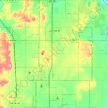
Name: Glenpool topographic map, elevation, terrain.

Location: Glenpool, Tulsa County, Oklahoma, 74033, United States (35.87125 -96.03339 35.98838 -95.95807)

Average elevation: 732 ft

Minimum elevation: 587 ft

Maximum elevation: 965 ft

Tulsa County trails, hiking, mountain biking, running and outdoor activities

Other topographic maps

Click on a map to view its topography, its elevation and its terrain.

Haikey Creek

United States > Oklahoma > Tulsa County > Broken Arrow

Average elevation: 666 ft

Turley

United States > Oklahoma > Tulsa County

Average elevation: 676 ft

Southern Reserve

United States > Oklahoma > Tulsa County > Jenks

Average elevation: 646 ft

Gear up for your next adventure:

🛰️Handheld GPS Units - Professional satellite navigators for precise backcountry mapping
👟Men's Trail Runners - Lightweight footwear for fast-paced exploration and light hiking
🛶Inflatable Kayak - Portable kayak for rivers, lakes, and expeditions
🛰️Satellite Messengers - Emergency SOS and two-way messaging for off-grid adventures
🧢Outdoor Hiking Hat - Sun protection hat for outdoor explorers

As an Amazon Associate, this site earns from qualifying purchases at no extra cost to you.