
Make a donation
Gear up for your next adventure:
As an Amazon Associate, this site earns from qualifying purchases at no extra cost to you.
Isla de Maipo topographic map
Click on the map to display elevation.
Make a donation
Gear up for your next adventure:
As an Amazon Associate, this site earns from qualifying purchases at no extra cost to you.
About this map
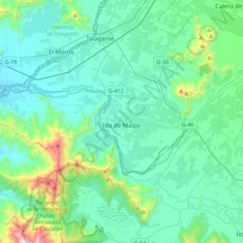
Name: Isla de Maipo topographic map, elevation, terrain.
Average elevation: 1,473 ft
Minimum elevation: 764 ft
Maximum elevation: 5,476 ft
Make a donation
Gear up for your next adventure:
As an Amazon Associate, this site earns from qualifying purchases at no extra cost to you.
Other topographic maps
Click on a map to view its topography, its elevation and its terrain.
El Peumo
Chile > Santiago Metropolitan Region > Provincia de Talagante > Talagante
Average elevation: 1,063 ft
Santa Mónica Norte
Chile > Santiago Metropolitan Region > Provincia de Talagante
Average elevation: 1,598 ft
Don Benedicto
Chile > Santiago Metropolitan Region > Provincia de Talagante > Peñaflor
Average elevation: 1,365 ft