
Make a donation
Gear up for your next adventure:
As an Amazon Associate, this site earns from qualifying purchases at no extra cost to you.
Cobbler topographic map
Click on the map to display elevation.
Make a donation
Gear up for your next adventure:
As an Amazon Associate, this site earns from qualifying purchases at no extra cost to you.
About this map
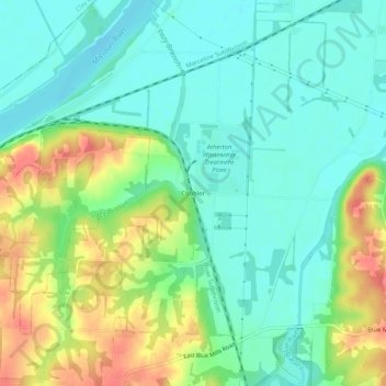
Name: Cobbler topographic map, elevation, terrain.
Location: Cobbler, Jackson County, Missouri, 64058, United States (39.14362 -94.34828 39.18362 -94.30828)
Average elevation: 778 ft
Minimum elevation: 705 ft
Maximum elevation: 915 ft
Make a donation
Gear up for your next adventure:
As an Amazon Associate, this site earns from qualifying purchases at no extra cost to you.
Other topographic maps
Click on a map to view its topography, its elevation and its terrain.
Kansas City
United States > Missouri > Jackson County
Kansas City features a diverse topography characterized by rolling hills and valleys, with elevations ranging from about 794 to 997 feet above sea level. The landscape is shaped by the confluence of the Missouri and Kansas rivers, resulting in a mix of elevated areas and flat river plains. The region's average…
Average elevation: 909 ft
Lee's Summit
United States > Missouri > Jackson County
When the surveyors for the Missouri Pacific Railroad came through, the local people and the railroad wanted to name the town in Dr. Lea's honor. He had a farm on the highest point and near the path of the tracks, and his murder had taken place near the site of the proposed depot. So they chose the name of…
Average elevation: 955 ft
Make a donation
Gear up for your next adventure:
As an Amazon Associate, this site earns from qualifying purchases at no extra cost to you.
Make a donation
Gear up for your next adventure:
As an Amazon Associate, this site earns from qualifying purchases at no extra cost to you.
Richard L. Berkley Riverfront Park
United States > Missouri > Jackson County > Kansas City
Average elevation: 794 ft
Lee's Summit
United States > Missouri > Jackson County
When the surveyors for the Missouri Pacific Railroad came through, the local people and the railroad wanted to name the town in Dr. Lea's honor. He had a farm on the highest point and near the path of the tracks, and his murder had taken place near the site of the proposed depot. So they chose the name of…
Average elevation: 955 ft
Make a donation
Gear up for your next adventure:
As an Amazon Associate, this site earns from qualifying purchases at no extra cost to you.
Make a donation
Gear up for your next adventure:
As an Amazon Associate, this site earns from qualifying purchases at no extra cost to you.
Make a donation
Gear up for your next adventure:
As an Amazon Associate, this site earns from qualifying purchases at no extra cost to you.
Make a donation
Gear up for your next adventure:
As an Amazon Associate, this site earns from qualifying purchases at no extra cost to you.
Lee's Summit
United States > Missouri > Jackson County
When the surveyors for the Missouri Pacific Railroad came through, the local people and the railroad wanted to name the town in Dr. Lea's honor. He had a farm on the highest point and near the path of the tracks, and his murder had taken place near the site of the proposed depot. So they chose the name of…
Average elevation: 955 ft
Make a donation
Gear up for your next adventure:
As an Amazon Associate, this site earns from qualifying purchases at no extra cost to you.