Geolocate

Trayu topographic map

Click on the map to display elevation.

About this map

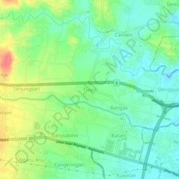
Name: Trayu topographic map, elevation, terrain.

Location: Trayu, Boyolali, Central Java, Java, 57373, Indonesia (-7.54386 110.67707 -7.50386 110.71707)

Average elevation: 525 ft

Minimum elevation: 449 ft

Maximum elevation: 669 ft

Other topographic maps

Click on a map to view its topography, its elevation and its terrain.

Selo

Indonesia > Central Java > Boyolali

Average elevation: 4,731 ft

Kecamatan Ngemplak

Indonesia > Central Java > Boyolali

Average elevation: 413 ft

Jrakah

Indonesia > Central Java > Boyolali

Average elevation: 5,148 ft

Klakah

Indonesia > Central Java > Boyolali

Average elevation: 4,058 ft

Lencoh

Indonesia > Central Java > Boyolali

Average elevation: 5,486 ft

Musuk

Indonesia > Central Java > Boyolali

Average elevation: 2,356 ft

Gear up for your next adventure:

Camping Coffee Makers - Enjoy premium coffee at the summit or campsite
🕶️GPS Smartphone Mount - Secure mount for phone navigation
🚑Emergency Bivvies - Heat-reflective sleeping bags for survival situations
📦Gear Storage Bags - Organize and protect outdoor equipment
🧣Hiking Neck Gaiter - Multi‑use neck protection for outdoor weather

As an Amazon Associate, this site earns from qualifying purchases at no extra cost to you.